
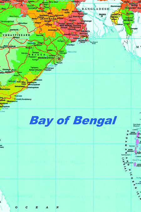
The Bay of Bengal (BoB) is a bay in the Indian Ocean’s northeastern region. It has the shape of a triangle and is bordered on the east by the Malay Peninsula and on the west by India. The Bengal area, which includes the Indian state of West Bengal and the country of Bangladesh, is located on the northern tip of the “bay,” hence the name. The southernmost reaches Sri Lanka’s island nation and the Indian Union Territory of the Andaman and Nicobar Islands.
The Ganges River (or Ganga), Meghna River, and Brahmaputra River rivers run west to east into the Bay of Bengal, as do the Mahanadi River through the Mahanadi River Delta, Godavari River, Krishna River, Irrawaddy, and Kaveri River (often spelt as Cauvery) rivers in the south. On the Bay of Bengal, the Sundarbans mangrove forest is formed at the confluence of the Ganga, Brahmaputra, and Meghna rivers. Myanmar’s Ayeyarwady River also feeds into the bay.
The Andaman, Nicobar, and Mergui groups are among the many islands in the bay. Cheduba and neighbouring islands in the northeast, off the coast of Myanmar, are notable for a network of mud volcanoes that are periodically active.
Cox’s Bazar, on the bay’s northeastern shore, has one of the world’s longest continuous natural beach. Bakkhali, Digha, Chandipur, Puri, Waltair, and Marina Beach in Chennai are some of the other beaches around the bay.
The climate
The climate in the Bay of Bengal is mainly dominated by the monsoons. From November to April, the northeast winds (the northeast monsoon) blow over the northern part of the bay. This is produced as a result of a continental high-pressure system. And from June to September, the rain-bearing southwest monsoon prevails, as intense heat produces a low-pressure system over the sub-continent, and as a result, air flows over the ocean. During spring (April- May) and fall (October- November), tropical storms of high winds and heavy rainfall in the form of cyclones occur over the Bay of Bengal.
Geopolitical and geostrategic positioning
Bay of Bengal lies at the centre of 2 huge economic blocks, the SAARC and ASEAN. This influences China’s southern landlocked region in the north and major seaports of India and Bangladesh. China, India, and Bangladesh have established naval cooperation agreements with Malaysia, Thailand, and Indonesia to increase cooperation in checking terrorism on the high seas.
Physical properties of BoB
A distinctive feature of the bay is its utmost variability of physical properties. In the offshore areas, the temperature is however warm and markedly uniform in all seasons which somewhat decreases towards the north. Surface densities are comparatively greater in spring than in fall when the river discharge is the highest. An oxygen-poor intermediate layer is present below the surface layer which has high salinity and undergoes weak circulation. Quite weak outbursts occur in the northeast during the northeast monsoon.
Surface movements of the waters keep changing the directions along with the seasons. The northeast monsoon encourages a clockwise circulation while the southeast monsoon results in a counter-clockwise circulation. Severe storms occur at the change of the monsoon, particularly to the south in October.
In addition to water level changes resulting from waves and tide, the average sea level varies throughout the year. The bay also experiences occasional tsunamis. One such event, caused by an undersea earthquake near the Indonesian island of Sumatra in December 2004, devastated extensive coastal areas of the bay, particularly in Sri Lanka and the Andaman and Nicobar Islands.
Sediments in the Bay of Bengal are subjected to terrigenous deposits from the rivers that are derived mainly from the Indian subcontinent and the Himalayas. Calcareous clays and oozes are found near the Andaman and Nicobar Islands and above the Ninety East Ridge.
The age of exploration
An early Greek manual named the Periplus of the Erythraean Sea, written in the 1st century AD describes the sailing routes from the Red Sea (Maris Erythraei) to the coastal areas along the Arabian Sea and Bay of Bengal to eastern India north of the Ganges delta. During the 2nd century AD, Ptolemy described voyages from the Ganges across the Bay of Bengal to the Strait of Malacca.
As per the information provided by Ptolemy, it is assumed that Indian and Malayan sailors had been crossing the Bay of Bengal on trading voyages for quite some time.
The colonising voyages began in the 1st century AD and can be divided into 2 periods: gradual colonisation between the 1st and 6th centuries and development journeys between the 7th and 10th centuries.
The Chinese maritime dominance of the Bay of Bengal began during the Nan (Southern) Song Dynasty (1127-1279).
The famous Vasco Da Gama was the first man to lead the first European voyage to India. Later, the other major European voyages from the 16th to 19th century passed well to the south of the Bay of Bengal.
By the 20th century, especially after World War II, interest in the scientific study regarding the Bay had grown. An initiative was taken by the National Institute of Oceanography, established in India in 1966, to extend the research by utilising the vessels Sagar Kanya and Gaveshani.
BoB’s economic resources
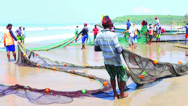
The Bay of Bengal has been gifted with a distinct tropical marine ecosystem. As a result of huge river drainage into the northern part of the bay and the presence of wetlands, marshes and mangroves increase the productivity of fish species. Activities like small-scale fisheries and commercial fishing in deeper waters done largely by countries bordering the bay are proving to be hazardous for these marine lives. Despite being the major export crop, the annual catch of prawns has remained stable, although its harvesting has intensified. Another important fish found in the bay is tuna.
Other important discoveries in the bay, notably offshore of the Godavari and Mahanadi deltas, include the discoveries of petroleum and natural gas. Hydrocarbon resources are found in the deeper areas of the Bay of Bengal, as compared to those in the Arabian Sea. Apart from this, placer deposits of titanium and rare earth are found off northeastern Sri Lanka and northeastern India respectively. Also, heavy mineral sands that consist of ilmenite, garnet, sillimanite, zircon, rutile, and manganite are found around Nagapatnam (in Tamil Nadu state) on the southeastern Indian coast, near Chennai (Madras) and in coastal areas around Vishakhapatnam.
Trade across and beyond the Bay of Bengal
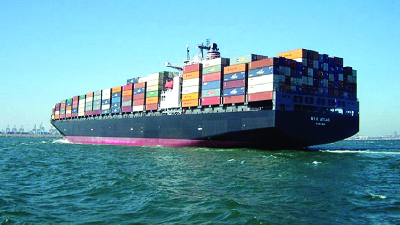
Oceanic transportation is limited to carrying cargoes to and from Sri Lanka, Bangladesh, and the east- coast of India. Principal ports on the east coast of India are Kolkata, Haldia, Vishakhapatnam, Chennai, Cuddalore, and Paradeep. Important ports of Sri Lanka are Colombo and Trincomalee. In Bangladesh, the major ports are Chittagong Port, Mongla, Payra, and Matarbari, while Myanmar’s chief port on the Bay of Bengal is Akyab. Haldia, Vishakhapatnam, and Paradeep are well developed as iron ore terminals, reflecting India’s profitable exportation of raw materials.
Bangladesh, BoB and Blue Economy
Bangladesh has already taken up certain steps to boost up Blue Economy in the Bay of Bengal region. One such example is the development of the deep seaport Matarbari Port Development Project (MPDP) in Bangladesh. Additionally, the Japan International Cooperation Agency (JICA) has agreed to provide fund for the project and a Japanese consulting company- Nippon Koei Joint Venture, has been selected to provide engineering-related services.
By 2026, the MPDP is expected to start its commercial operations and will be in a position to receive 8,500 TEU post-Panamax vessels. Plans have also been made to enhance the port’s capacity to 2.8 million TEUs annually by adding more berths in the future. Under the influence of MPDP, Bangladesh and the Bay of Bengal region are expected to benefit from at least 2 spin-offs. First of all, it will help Bangladesh to reduce her dependency on the feeder vessels to ferry export-import goods from different foreign ports. Nearly 90% of Bangladesh’s trade is carried onboard ships that operate in 3 ports- Chittagong, Mongla, and Payra. In 2017-18, Chittagong Port accounted for 98.43% of Bangladesh’s seaborne container trade, and the balance was moved through Mongla Port.
Secondly, the MPDP paves the way for short sea shipping in the Bay of Bengal. According to Bangladesh’s State Minister for Shipping, Khalid Mahmud Chowdhury, the MPDP could develop as a “regional transshipment hub of connectivity.” Short sea shipping in the Bay of Bengal region has been in demand in the regional countries’ agenda and a start has been made with the commencement of services between Port Blair in India’s Andaman and the Nicobar Islands and Aceh in Sumatra, Indonesia.
A call to unite
A common scenario among the littoral states of the Bay of Bengal is that most of the countries are known as rising economies. The sea lies at the centre of two behemoth economic blocks, South Asia and Southeast Asia. The maritime domain of the Bay of Bengal is expected to contribute to littoral states immensely towards the growth of prosperity. Sustainable use and management of fishery resources of the Bay of Bengal would promote the creation of employment and food security. Judicious management of the expanding offshore oil and gas industry of the region can also spur socio-economic development and thus enhance South Asia littoral states’ energy security.
The perspective of Bangladesh
Right after the independence, the Father of the Nation Bangabandhu Sheikh Mujibur Rahman, as he was desperately seeking new resources to build up the war-torn nation, his vision extended over the horizon of the mighty blue waves of the Bay of Bengal and he instantly foresaw the possibilities lying in it. To claim our legal rights in the ocean, Bangabandhu promulgated the ‘Territorial Waters and Maritime Zones Act, 1974’ (Act no. XXVI of 1974) which eventually paved the way for the proper management and protection of coastal marine resources today.
About 30 million people in the country directly depend on economic activities related to the ocean. Hence, the concept of a Blue Economy has been placed high on the national sustainable development agenda of Bangladesh. The policymakers are giving priority to tying up nexus with other states and international organisations that are working in the field of ocean research and resources.
From Bangladesh’s perspective, cooperation in Blue Economy refers to collaboration in the sphere of research, surveillance, and information sharing that should take place based upon the accepted universal principles of engagement, i.e. mutual trust, respect, mutual benefits, and equitable sharing of benefits.
Blue Economy, leading all the way
The Ministry of Foreign Affairs of Bangladesh has been spearheading the Blue Economy concept in the regional and international arena. In September 2014, the Ministry of Foreign Affairs of Bangladesh organised an international workshop on the Blue Economy. The purpose of organising such an event was to discuss ways for proper exploration of untapped resources in the Bay of Bengal. In 2016, during the 37th session of the SAARC Council of Ministers meeting in Nepal, concept notes on Blue Economy had been circulated by Bangladesh to get the opinions of the South Asian states. Such endeavour is the initial attempt of Bangladesh to host an expert-level meeting on the Blue Economy within the South Asia region. A similar intention was reiterated by the Honourable Prime Minister of Bangladesh at the 18th SAARC Summit in Nepal.
Oceans and seas are deemed as global commons. For that reason, Bangladesh proceeds onward with the vision of the ’Bay of Bengal Partnership for Blue Economy’ to ensure sustainable development among the littoral states of the region.
Bangladesh is putting together policy guidelines to improve its maritime capabilities. Such efforts include navy modernisation, the construction of a maritime university, and chairing and participating in naval symposiums and debates. Bangladesh has added the BNS ANUSHANDHAN to its navy fleet to conduct maritime research and hydrographic and oceanographic surveys. The Honourable Prime Minister of Bangladesh commissioned the research vessel ‘RV ‘Meen Shandhani’ on November 19, 2016. As a result of the survey’s findings, Bangladesh is better positioned to design a plan for the long-term exploration and utilisation of marine resources protected beneath the Bay of Bengal’s mighty blue waves.


