
‘Hydro’ is a Greek word that means water, while ‘graph’ is also a Greek word that means image. To put it another way, hydrography is the study of water depth, impediments beneath the water as well as the actual form and features of water movement utilising charts. This applied science’s purpose is to accurately describe the physical characteristics of coastline areas and the bottom of rivers, seas as well as other water bodies. Hydrographic data is collected using a variety of technologies. Water levels and tides, water currents, temperature, salinity and other variables are among the information collected. These data are used to build nautical charts and hydrographic models. Its utility isn’t restricted to the creation of nautical charts and publications, though. Rather, hydrography has a distinctive relationship with all aspects of marine science and oceanography, including the exploration and exploitation of marine resources, environmental conservation and management, maritime planning, tsunami and tidal modelling, coastal zone management, marine tourism and maritime defence. Therefore, it is necessary to acknowledge its true significance.
Hydrography as a global practice
Hydrography is not just a matter of practice in a particular region or a particular country. Rather, in this age of globalisation, it has become global practice. There is an international obligation to provide hydrographic services. All member countries of the SOLAS (Safety of Life at Sea) Convention are required to provide hydrographic services for the safe navigation of ships.
The International Hydrographic Organisation (IHO) celebrates World Hydrography Day on 21 June every year. The theme of World Hydrography Day-2021 was ‘One Hundred Years of International Cooperation in Hydrography’. The importance of hydrography in safe navigation has long been recognised around the world, as reflected by the theme and worldwide actions have been initiated in response. Besides, hydrographic companies, industry stakeholders and specialists have collaborated and worked tirelessly to obtain a greater understanding of the sea.
Technology’s impact on hydrography
The use of hydrography in identifying the borders of any port is essential. Although hydrography was initially practised manually, technology has made it easier in the present period. The assessments are now being carried out through topographical surveys using the Differential Global Positioning System or DGPS. There are four types of equipment used in this work. These are – positioning instruments, depth measuring instrument, motion sensor equipment and tide gauge equipment.
In addition, some more supporting instruments are used for hydrographic surveys. E.g. Side-scan sonar, sub-bottom profiler, sediment profile imagery, Remotely Operated Vehicle (ROV), Acoustic Doppler Current Profiler (ADCP), automatic survey boat, bathymetric survey drones, LIDAR, sound velocity profiler and use of software for hydrographic work.
The practice of hydrography in Bangladesh
The government has entrusted the important responsibility of maritime surveys to Bangladesh Navy, while Bangladesh Inland Water Transport Authority (BIWTA) is in charge of surveying the country’s inland waters. And the seaport authorities of the country are responsible for surveying the areas under their jurisdiction.
Bangladesh Navy has already completed the maritime survey of Bangladesh and is undertaking updated survey activities every year to ensure safe navigation. In addition, the port authorities of Chittagong, Mongla, and Payra each have a survey department with contemporary survey equipment and trained personnel. The National Hydrographic Committee (NHC) was established by the government in 2001 to manage all hydrographic and maritime activities in Bangladesh. The committee is chaired by the Assistant Chief of Naval Staff (Operations) of Bangladesh Navy and includes representatives from several ministries and agencies. The NHC has been actively working to enhance cooperation between different organisations to make the best possible use of the country’s maritime resources.
Hydrography and Bangladesh Navy
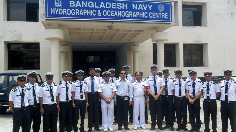
Ocean surveying is a modern technology-based activity, which is constantly changing. As a result, international cooperation and coordination are important for the successful use of new hydrography technologies at sea. Bangladesh Navy maintains close bilateral relations with all international hydrographic organisations. In 1996, Bangladesh Navy began modernising its hydrography services in collaboration with the French government. The collaborative activities began with the goal of providing modern equipment to Bangladesh and developing technical abilities in the field of hydrography. The second phase was completed in 2001. Bangladesh Navy’s hydrographic service launched digital surveys with technical assistance from the French government. Bangladesh Navy Hydrographic School at BNS ISSA KHAN in Chattogram has been recognised by the International Board on Standards of Competence (IBSC) for conducting Category ‘B’ courses since 2005. It is Bangladesh’s sole institute that offers formal hydrography training that meets international standard. Hydrographers from the country’s numerous government agencies, as well as trainees from IHO member states, undergo training here.
Bangladesh Navy has already achieved the capability and success of creating paper and Electronic Nautical Charts (ENC) as per IHO standard. So far, Bangladesh Navy has released 53 nautical charts and 11 electronic navigational charts, including nine international series charts of the seas under its jurisdiction, all of which have received national and worldwide appreciation. These maps are frequently used for safe navigation at sea.
In 2010, a Memorandum of Understanding (MoU) was signed between Bangladesh Navy and the United Kingdom Hydrography Office (UKHO). The UKHO is disseminating an international series of paper charts of Bangladesh’s maritime domain, which are based on Navy surveyed data and are used for safe navigation of all ships at home and abroad.
Hydrography keeps Chittagong port operational
Chittagong port serves as the country’s main entry and exit point for import and export. The Karnaphuli river is the lifeline of this port. The Hydrography Department of the Chittagong Port Authority makes a significant contribution to the year-round navigation of the Karnaphuli river. This department is always doing activities to keep the river safe for navigation, obtaining any kind of advanced idea for the river’s development and maintaining the river’s environment for all those who utilise it.
The Hydrography Department monitors the Karnaphuli river’s behaviour and determines what is needed to maintain the channel properly. Since its inception, hydrographic survey and research data on the character of the sea and river have played a critical role in maintaining the port operational and active. In order to keep the navigation of ships at Chittagong port smooth and easy, first of all, it is needed to keep the navigability of the river normal. And, to keep the river navigable throughout the year, the Hydrography Department must continue its regular activities and take the appropriate steps.
The Hydrography Department at Chittagong port is responsible for ensuring that survey activities are carried out throughout the year. These activities cover a 30 km radius from 2.5 km upstream of the Kalurghat bridge to Patenga lighthouse, as well as a sea area of 13 km radius from Patenga lighthouse. In addition, an area of 80 km to the south and 50 km to the north of Patenga lighthouse will be surveyed, according to the government gazette of 2019. Necessary data of the river is collected from the permanent auto-tide gauge stations located at the six points of the Karnaphuli channel. The sandbanks are leased on a yearly basis in order to extract sand and preserve the navigability of the river. To keep the port navigable, the Hydrography Department conducts maintenance dredging and it is also a responsibility of the Hydrography Department to guarantee that the slipway area is navigable at all times.
The Hydrography Department publishes the data obtained through bathymetric surveys through bathymetric charts and identifies submerged wrecks and other objects at the bottom of the river. The Hydrography Department of Chittagong port uses modern technology and software in its survey and dredging work. These include DGPS for positioning, multibeam and single-beam echo sounders for measuring river depth, sound velocity metres, current metres for determining the velocity and direction of river currents, scan sonar to locate submerged debris and objects, sub-bottom profiler for determining the size of submerged objects at the bottom of the river and digital level for levelling survey. In addition, HYPACK is used for hydrographic surveys, data processing and chart publishing; DREDGEPACK is used to calculate the amount of dredging; CARIS-GIS is used for topographic survey data processing and chart publishing and GeoTide software is used for tidal data analysis and prediction.
The total activities of the Chittagong port’s Hydrography Department are carried out through five branches. These are the River Survey section, Gauge Reading section, Establishment section, Survey Ship section and Dredger section. A chief hydrographer is the head of the Hydrography Department. Besides, the department has a total staff of 26 people including senior hydrographer, hydrographer, senior dredging master, electrical engineer, chief engineer and others. The Hydrography Department now operates seven survey vessels. Two security vessels and a dredger are also being operated by the department.
Dredging challenges in Karnaphuli river
To keep import-export trade in Chittagong port normal, the Karnaphuli river’s navigability must be maintained. Dredging is essential for both capital and maintenance purposes. So far, the Hydrography Department of Chittagong port successfully removed 2,100,000 cubic metres of sediment in 1980 from the downstream area, with 1,800,000 cubic metres removed in 1988. In addition, another phase of capital dredging was initiated in 2011. However, due to various complications, that work has not been completed yet.
The Chittagong Port Authority signed a contract with the Malaysian Maritime and Dredging Corporation in 2011 for capital dredging in the Karnaphuli river. However, due to polythene waste-related issues at the river’s bottom, the company was unable to complete the project. From China, the Malaysian organisation brought large dredgers. However, the dredger’s cutting blade became trapped in polythene on several occasions, causing the activities to be disrupted.
The Chittagong Port Authority cancelled the contract with the Malaysian company in 2013 due to work being stopped. Later, the authority altered the project’s name and decided on dredging once again. The Karnaphuli Capital Dredging Project has been renamed as ‘Sadarghat to Bakliarchar Dredging Project’.
According to Hydrography Department sources, an agreement was reached between Chittagong Port Authority and Bangladesh Navy in May 2018 to implement the dredging project. E-Engineering Limited, a subsidiary of Saif Powertech Limited, a local company, is working on the project under the supervision of Bangladesh Navy. The project, that started on 17 October 2018, is expected to be completed by May 2022.
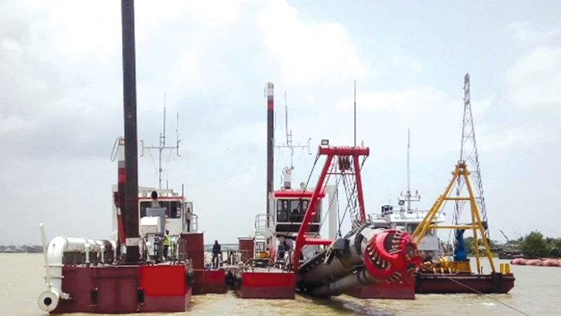
A pile of polythene waste has grown up to 25 feet in certain areas in the Chattogram metropolitan area of the Karnaphuli river. To remove this waste, dredging is currently being conducted with domestic technology. Two types of dredgers are now at work. Three grab dredgers and ten to twelve standard dredgers are among them. A grab dredger is used to remove the polythene and waste first. After that, a regular dredger is used to excavate.
This project aims to remove 5,100,000 cubic metres of sediment and garbage to safeguard the navigability of the Karnaphuli river and ensures continued shipping at Chittagong port. Already, 3,250,000 cubic metres of sediment and waste have been removed.
According to Chittagong port sources, the initial project cost for capital dredging was estimated at BDT 3020 million. Later it was reduced to BDT 2950 million. This dredging is taking place along of the Chittagong port’s four-kilometre boundary. When this dredging will be completed, not only will shipping be risk-free, but a big area will be filled with soil and sand from the river, where a lighterage jetty will be built in the future. In this regard, BUET experts are working on a feasibility study.
Besides capital dredging, maintenance dredging work is also carried out regularly at Karnaphuli river by the Hydrography Department of the Chittagong Port Authority. Every year, suction dredging removes 110,000 cubic metres of sediment from the front of the jetty and 1,500,000 cubic metres of sediment from the outer bar and Karnaphuli channel. The Hydrography Department is also in charge of dredging in front of important canals such as the Chaktai and Rajakhali of the Karnaphuli river in order to relieve waterlogging in Chattogram city.
BIWTA for safe inland waterways
Bangladesh Inland Water Transport Authority (BIWTA) is in charge of ensuring that the country’s inland waterways are navigable. The authority, which is overseen by the Ministry of Shipping, has a Hydrography Department. This department has a total of 254 employees, with a director serving as the department’s head.
The Hydrography Department at BIWTA performs a variety of duties and operations, including:
• To prepare all types of hydrographic surveys and charts of inland and coastal waterways
• To conduct hydrographic surveys for installation of buoys, lights and beacons for safe navigation of waterways
• To conduct bundling surveys, coastal surveys as well as pre and post-dredging hydrographic surveys to maintain the required navigability
• To collect and store round-the-clock gauge data through radar sensors at 54 gauge stations in inland and coastal areas of the country
• To use collected gauge data in compiling hydrographic survey charts
• To collect and analyse gauge data, publish annual tide table and supply/sell as per demand
• To determine the distance between different places of the waterways, publish it in the form of a booklet and supply it as per the demand of public-private organisations
• To supply/sell the collected gauge data to various research and educational institutes as per demand
• To provide technical assistance to the Ministry of Foreign Affairs in compiling gauge data and preparing co-tidal charts for identification of continental shelf, baseline in establishing maritime boundaries and Exclusive Economic Zones (EEZs)
• To create clear charts, publish them, keep them safe and supply/sell print copies on demand
• To transmit uninterrupted signal using artificial satellite- based positioning DGPS system
• To install, repair and maintain all relevant accessories of DGPS (transmitters, receivers, diesel generators, etc.) at office and field level
• To install, repair, and maintain all equipment (echo sounders, water level recorders, total stations, etc.) used in hydrographic surveys at office and field level
• To install, repair, and maintain all HF SSB and VHF sets used by the authority
• To provide technical assistance in collecting, installing, repairing, and maintaining various types of electronic equipment used by the authority
• To collect, install, repair and maintain all air conditioning devices and refrigerators used by the authority
• Acceptance and implementation of development projects
• To provide technical assistance to the Ministry of Shipping for the establishment of deep seaports
End thoughts
Bangladesh’s economic progress is dependent on the Bay of Bengal. The Bay of Bengal transports 94% of the country’s overall import and export. As a result, hydrographic survey data is essential for locating offshore mineral reserves, growing agricultural, fisheries, environmental and maritime sectors as well as performing research activities targeted at producing eco-friendly and sustainable new ways to boost output. Hydrography is paramount to achieving the Blue Economy’s full potential. Hydrographic data contributes significantly to the conservation of the marine environment and the defence of the country, in addition to ensuring safe navigation.
As a coastal country, Bangladesh’s hydrographic surveying organisations work ceaselessly to maintain the country’s waters navigable. Activities connected to the exploration and utilisation of marine resources will be intensified further in the future, with the demarcation of maritime boundaries with Myanmar and India. As a result, the need for hydrographic surveys will increase in the following days. To make the best use of limited resources and ensure safe navigation in Bangladesh’s waters, we must strengthen cooperation and coordination between the country’s hydrographic organisations as well as all river and sea users.


